"Birds-Eye View of Toronto" print by Peter Alfred Gross (1876)
"Birds-Eye View of Toronto" print by Peter Alfred Gross (1876)
Couldn't load pickup availability
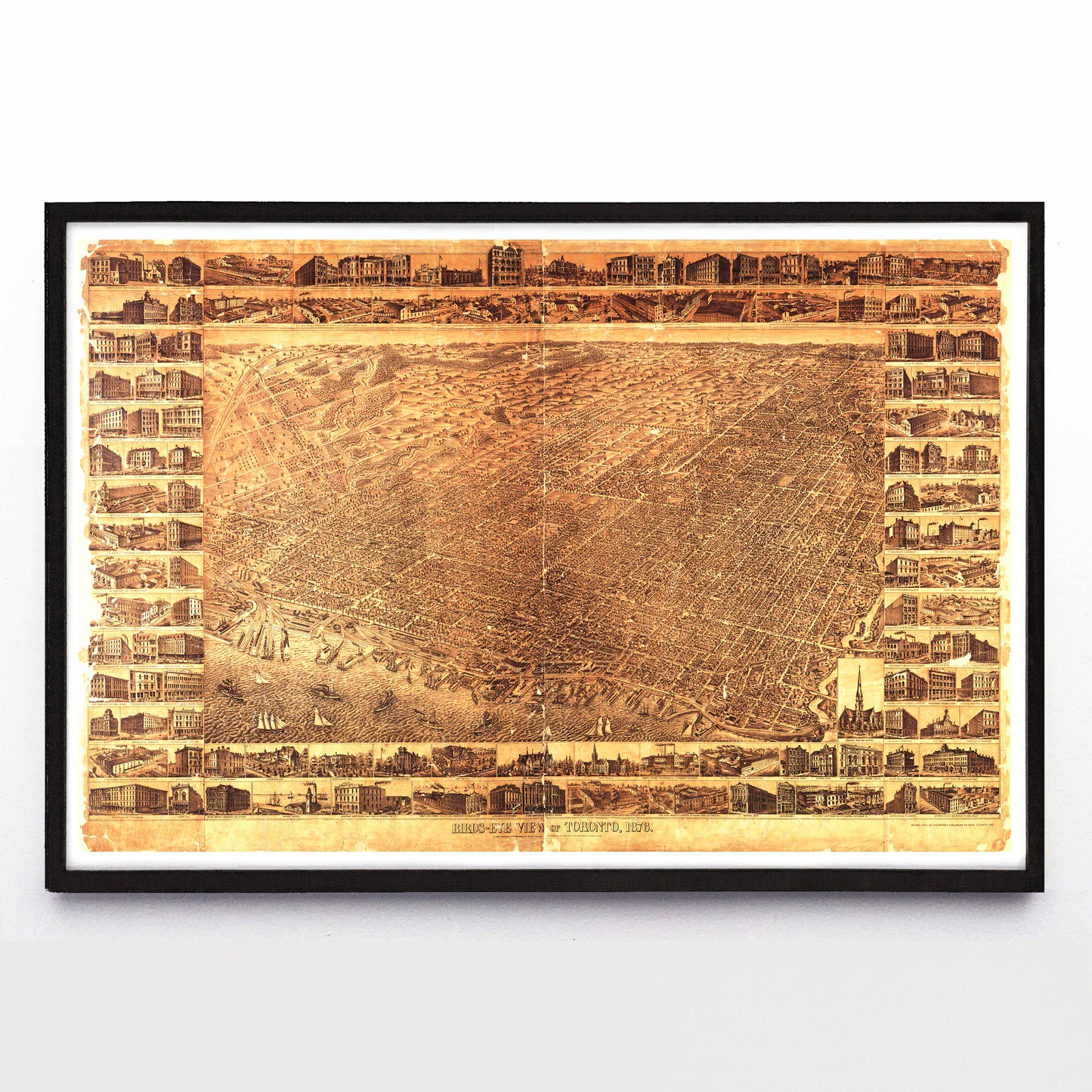
Of the 4500 bird’s eye view city prints mentioned in John Reps’ catalogue of the genre, around 350 are of Canadian cities, and Peter Alfred Gross’ 1876 Birds-eye View of Toronto print stands out among them for its intense level of detail.
Gross started research for the project shortly after arriving in Toronto from Pennsylvania in 1874, and the image shows a city intimately recorded. Its two meter width spans from Fort York in the west to the Don River in the east, and from Lake Ontario at bottom to modern-day Dupont Street up top. Within it are 14,000 specific buildings and 133 numbered points of interest, all framed by 124 vignettes showing public and private buildings of note.
The pictured Knox College (currently the University of Toronto’s Daniels Building) and St. Lawrence Hall still stand, but so many of the others have been lost to fire and demolition—time has not been kind to this copy of this print, nor its subject matter.
Uniquely, in 1877 Birds-Eye View of Toronto was joined by its own guidebook (simply titled Illustrated Toronto) consisting of 400 pages of text describing Toronto’s past and present by historian and local promoter J. Timperlake, and it also included further illustrations by Gross showing different views and closeups of featured buildings.
Though the publisher of both print and guide book (Copp, Clark & Co.) haven’t left behind any financial records, their multi-year support of the project suggests the map was a hit. For whatever reason, Gross didn’t stay in Toronto to enjoy its success: he left for Paris in 1878 where he would teach English, study painting, and exhibit at the very desirable Salon in Paris in 1883. While an artist like Albert Ruger’s career in urban view making could last decades and result in hundreds of views, Gross’ career was brief and deep—whatever enthusiasm compelled him to spend three years making this massive map of Toronto, it was soon replaced by enthusiasm for a different kind of artistry.
A reproduction available at 18x12" or 36x24" on Epson Enhanced Matte 192 gsm paper printed with Epson UltraChrome XD2 archival ink. Sold in an open edition, unframed. Based on this original public domain image held by the University of Toronto Libraries Map & Data Library.